User talk:Hoskir
REVISION REQUEST 3980
620.2.16 Stop and Yield Lines (MUTCD Section 3B.16)
Guidance. Stop lines should be used to indicate the point behind which vehicles are required to stop, in compliance with a traffic control signal.
Option. Stop lines may be used to indicate the point behind which vehicles are required to stop in compliance with a STOP (R1-1) sign, a Stop Here For Pedestrians (R1-5b or R1-5c) sign, or some other traffic control device that requires vehicles to stop, except YIELD signs that are not associated with passive grade crossings.
Yield lines may be used to indicate the point behind which vehicles are required to yield in compliance with a YIELD (R1-2) sign or a Yield Here to Pedestrians (R1-5 or R1-5a) sign.
Standard. Except as provided in MUTCD Section 8B.28, stop lines shall not be used at locations where drivers are required to yield in compliance with a YIELD (R1-2) sign or a Yield Here To Pedestrians (R1-5 or R1-5a) sign or at locations on uncontrolled approaches where drivers are required by State law to yield to pedestrians.
Yield lines shall not be used at locations where drivers are required to stop in compliance with a STOP (R1-1) sign, a Stop Here For Pedestrians (R1-5b or R1-5c) sign, a traffic control signal, or some other traffic control device.
Stop lines shall consist of solid white lines extending across approach lanes to indicate the point at which the stop is intended or required.
Stop lines shall be used in advance of railroad crossings to indicate the appropriate location to stop.
When any crosswalk is installed where a permanent traffic control device is provided, such as a STOP sign or traffic signal, a stop line shall be installed in advance of the crosswalk.
Stop lines shall be 24 in. wide and shall extend across all lanes affected by the traffic control device.
Yield lines shall consist of a row of solid white isosceles triangles pointing toward approaching vehicles extending across approach lanes to indicate the point at which the yield is intended or required. The spacing of triangles in a yield line shall be consistent for that marking.
Guidance. Yield lines should be 24in. wide by 36in. long with 12 in. spacing between triangles, as shown on Standard Plan 620.00. Yield line triangles are paid for per each individual triangle. A yield line, for a lane that is 10 ft. or narrower, will consist of 4 individual triangles spaced accordingly.
Yield lines may be considered for those locations where a free right turn lane is developed but there is not an acceleration lane on the intersecting road. Yield lines may also be considered at on ramps with tapered acceleration lanes as shown in Fig. 620.2.5.3, Examples of Dotted Lined and Channelizing Line Applications for Entrance Ramp Markings.
Yield lines may also be used where engineering judgment indicates a need.
Guidance. If used, stop and yield lines should be placed a minimum of 4 ft. in advance of the nearest crosswalk line at controlled intersections, except for yield lines at roundabouts as provided for in EPG 620.3.4 Yield Lines for Roundabouts and at midblock crosswalks. In the absence of a marked crosswalk, the stop line or yield line should be placed at the desired stopping or yielding point, but should not be placed more than 30 ft. nor less than 4 ft. from the nearest edge of the intersecting traveled way. Stop lines should be placed to allow sufficient sight distance to all other approaches to an intersection.
When a stop line is used in conjunction with the STOP sign it should be placed adjacent to, or in line with, the STOP sign.
When a yield line is used in conjunction with the YIELD sign it should be placed adjacent to, or in line with, the YIELD sign.
Stop lines at midblock signalized locations should be placed at least 40 ft. in advance of the nearest signal indication.
If yield or stop lines are used at a crosswalk that crosses an uncontrolled multilane approach, the yield lines or stop lines should be placed 20 to 50 ft. in advance of the nearest crosswalk line, and parking should be prohibited in the area between the yield or stop line and the crosswalk (see Figure 620.2.17.1 Examples of Yield Lines at Unsignalized Midblock Crosswalks).
Standard. If yield (stop) lines are used at a crosswalk that crosses an uncontrolled multi-lane approach, Yield Here To (Stop Here For) Pedestrians (R1-5 series) signs (see EPG 620.2.11 Raised Pavement Markers) shall be used.
Guidance. Yield (stop) lines and Yield Here To (Stop Here For) Pedestrians signs should not be used in advance of crosswalks that cross an approach to or departure from a roundabout.
Support. Drivers yielding or stopping too close to crosswalks that cross uncontrolled multi-lane approaches place pedestrians at risk by blocking other drivers’ views of pedestrians and by blocking pedestrians’ view of vehicles approaching in the other lanes.
Option. Stop and yield lines may be staggered longitudinally on a lane-by-lane basis. Refer to "D" of Fig. 620.2.8.2.
Support. Staggered stop lines and staggered yield lines can improve the driver's view of pedestrians, provide better sight distance for turning vehicles and increase the turning radius for left-turning vehicles.
EPG 620.2.25 Stop and Yield Lines at Highway-Rail Grade Crossings contains information regarding the use of stop lines and yield lines at grade crossings.
620.2.24 Pavement Markings for Highway-Rail Grade Crossings (MUTCD Section 8B.27)
Standard. All grade crossing pavement markings shall be retroreflectorized white. All other markings shall be in accordance with EPG 620 Pavement Marking.
On paved roadways, pavement markings in advance of a grade crossing shall consist of an X, the letters RR, a no-passing zone marking (on two-lane, two-way highways with centerline markings in compliance with EPG 620.2.1), and certain transverse lines as shown in Fig. 620.2.25.1, Example of Placement of Warning Signs and Pavement Markings at Grade Crossings and Fig. 620.2.25.2, Grade Crossing Pavement Markings.
Identical markings shall be placed in each approach lane on all paved approaches to grade crossings where signals or automatic gates are located, and at all other grade crossings where the posted or statutory highway speed is 40 mph or greater.
Pavement markings shall not be required at grade crossings where the posted or statutory highway speed is less than 40 mph if an engineering study indicates that other installed devices provide suitable warning and control. Pavement markings shall not be required at grade crossings in urban areas if an engineering study indicates that other installed devices provide suitable warning and control.
Guidance. When pavement markings are used, a portion of the X symbol should be directly opposite the Grade Crossing Advance Warning sign. The X symbol and letters should be elongated to allow for the low angle at which they will be viewed.
Option. When justified by engineering judgment, supplemental pavement marking symbol(s) may be placed between the Grade Crossing Advance Warning sign and the grade crossing.
620.2.25 Stop and Yield Lines at Highway-Rail Grade Crossings (MUTCD section 8B.28)
Standard. On paved roadways at grade crossings that are equipped with active control devices such as flashing-light signals, gates, or traffic control signals, a stop line (see EPG 620.2.16) shall be installed to indicate the point behind which highway vehicles are or might be required to stop.
Guidance. On paved roadway approaches to passive grade crossings where a STOP sign is installed in conjunction with the Crossbuck sign, a stop line should be installed to indicate the point behind which highway vehicles are required to stop or as near to that point as practical.
If a stop line is used, it should be a transverse line at a right angle to the traveled way and should be placed approximately 8 ft. in advance of the gate (if present), but no closer than 15 ft. in advance of the nearest rail.
Option. On paved roadway approaches to passive grade crossings where a YIELD sign is installed in conjunction with the Crossbuck sign, a yield line (see EPG 620.2.16) or a stop line may be installed to indicate the point behind which highway vehicles are required to yield or stop or as near to that point as practical.
Guidance. If a yield line is used, it should be a transverse line at a right angle to the traveled way and should be placed no closer than 15 ft. in advance of the nearest rail (see Fig. 620.2.25.1, Example of Placement of Warning Signs and Pavement Markings at Grade Crossings).


REVISION REQUEST 3981
620.2.18 Crosswalk Markings (MUTCD Section 3B.18)
Support. Crosswalk markings provide guidance for pedestrians who are crossing roadways by defining and delineating paths on approaches to and within signalized intersections, and on approaches to other intersections where traffic stops.
In conjunction with signs and other measures, crosswalk markings help to alert road users of a designated pedestrian crossing point across roadways at locations that are not controlled by traffic control signals or STOP or YIELD signs.
At non-intersection locations, crosswalk markings legally establish the crosswalk.
Standard. When crosswalk lines are used, they shall consist of solid white lines that mark the crosswalk.
There are two styles of crosswalk markings: transverse and longitudinal (also known as continental). In most applications, the longitudinal markings are preferred and should be used to provide greater visibility, especially at midblock and uncontrolled crossings.
When used, longitudinal crosswalk markings shall be 24 inches wide and at least 6 feet in length, except that they shall be at least 8 feet in length at non-intersection crossings where the posted speed limit is 40 mph or greater.
If used, transverse crosswalk lines shall be no less than 6 inches wide and at least 6 feet apart
Guidance. Crosswalk lines, if used on both sides of the crosswalk, should extend across the full width of pavement or to the edge of the intersecting crosswalk to discourage diagonal walking between crosswalks.
At locations controlled by traffic control signals or on approaches controlled by STOP or YIELD signs, crosswalk lines should be installed where engineering judgment indicates they are needed to direct pedestrians to the proper crossing path(s).
Crosswalk lines should not be used indiscriminately. An engineering study should be performed before a marked crosswalk installed at a location away from a traffic control signal or STOP or YIELD signs. The engineering study should consider the number of lanes, the presence of a median, the distance from adjacent signalized intersections, the pedestrian volumes and delays, the average annual daily traffic (AADT), the posted or statutory speed limit or 85th-percentile speed, the geometry of the location, the possible consolidation of multiple crossing points, the availability of street lighting and other appropriate factors.
New marked crosswalks alone, without other measures designed to reduce traffic speeds, shorten crossing distances, enhance driver awareness of the crossing, and/or provide active warning of pedestrian presence, should not be installed across uncontrolled roadways where the speed limit exceeds 40 mph and either:
- A. The roadway has four or more lanes of travel without a raised median or pedestrian refuge island and an ADT of 12,000 vehicles per day or greater; or
- B. The roadway has four or more lanes of travel with a raised median or pedestrian refuge island and an ADT of 15,000 vehicles per day or greater.
Support. Chapter 4F of the MUTCD contains information on Pedestrian Hybrid Beacons. Section 4L.03 contains information regarding Warning Beacons to provide active warning of a pedestrian's presence. Section 4N.02 contains information regarding In-Roadway Warning Lights at crosswalks. Chapter 7D contains information regarding school crossing supervision.
Guidance. Because non-intersection pedestrian crossings are generally unexpected by the road user, warning signs (see Non-vehicular Sign (W11-2, W11-7)) should be installed and adequate visibility should be provided by parking prohibitions.
If used, the high-visibility longitudinal pedestrian crosswalk marking should consist of longitudinal bars 24 in. wide and spaced uniformly, centering one bar in each lane, and across each lane line, centerline, and edgeline (see Standard Plan 620.00).
When longitudinal bars are used to mark a crosswalk, the transverse crosswalk lines should be omitted. The marking design should avoid the wheel paths.
Existing 30 in. crosswalk bars should be replaced with 24 in. bars when the roadway is resurfaced.
Support. EPG 620.2.16 contains information regarding placement of stop line markings near crosswalk markings.
Option. Where permanent traffic control devices are not provided, speeds are greater than 35 mph or the crosswalk is located in rural locations where they are unexpected, the width of the crosswalk line may be increased up to 24 inches.
Crosswalks may be located mid-block if this placement offers greater safety to the pedestrian than the normal placement at an intersection. In these cases, the longitudinal bar pedestrian crosswalk marking should be used for greater emphasis and visibility. This type of marking may also be used at locations where substantial numbers of pedestrians cross without any other traffic control device, at locations where physical conditions are such that added visibility of the crosswalk is desired, or at places where a pedestrian crosswalk might not be expected.
Standard. All school crosswalks authorized by an agreement between the Commission and the school and/or city shall be marked. Crosswalks for schools shall be maintained in a manner that will provide a clearly visible marking at all times.
All school crosswalks shall be marked using both the advance school crosswalk and the school crosswalk sign, refer to EPG 903.18.8 School Sign (S1-1) and Plaques.
Option. When school crosswalks are located mid-block, the longitudinal bar pedestrian crosswalk marking should be used for greater emphasis and visibility.
Guidance. Crosswalk markings should be located so that the curb ramps are within the extension of the crosswalk markings.
Support. Detectable warning surfaces mark boundaries between pedestrian and vehicular ways where there is no raised curb. Detectable warning surfaces are required by 49 CFR, Part 37 and by the Americans with Disabilities Act (ADA) where curb ramps are constructed at the junction of sidewalks and the roadway, for marked and unmarked crosswalks. Detectable warning surfaces contrast visually with adjacent walking surfaces, either light-on-dark, or dark-on-light. The Americans with Disabilities Act Accessibility Guidelines for Buildings and Facilities (ADAAG) (see MUTCD Section 1A.11) contains specifications for design and placement of detectable warning surfaces.

REVISION REQUEST 3997
616.6.2.2 Flags and Advance Warning Rail System on Signs
Signs may be enhanced with flags, but only during daytime hours. Flags should not be used on signs at night, except that it is allowable to leave flags on signs when the work carries over from day to night.
Standard. When standard orange flags are used in conjunction with signs, they shall not block the sign face.
 |
616.23.1 Definitions
 |
Activity Area - Area of a temporary traffic control zone where work activity takes place. It is comprised of the work, traffic and buffer spaces.
Advance Warning Area - Area of a temporary traffic control zone where traffic is informed of the upcoming temporary traffic control zone.
Area Lighting - Lighting used at night to guide traffic through the temporary traffic control zone.
Annual Average Daily Traffic (AADT) - Volume of vehicular traffic using a section of highway on an average day.
Barricade - Temporary traffic control device consisting of one or three appropriately marked rails used to close, restrict or delineate all or a portion of the right of way.
Barrier-Mounted Sign - Sign mounted on a temporary or permanent traffic barrier.
Buffer Space - Area within the activity area free of equipment, material, and personnel used to provide lateral and/or longitudinal separation of traffic from the workspace or an unsafe condition.
Channelizer - Temporary traffic control device used to guide traffic or delineate an unsafe condition.

Crash Cushion - Temporary traffic control device used at fixed object and other desirable locations to reduce crash severity.
Daytime/Daylight - Period of time from one-half hour after sunrise to one-half hour before sunset.
Detour - Temporary rerouting of traffic onto an existing facility to avoid a temporary traffic control zone.
Diversion - Rerouting of traffic around an activity area using a temporary roadway or portions of an existing parallel roadway.
Divided Highway - Highway with physical separation of traffic in opposite directions.
Downstream Taper - Visual cue to traffic that access back into a closed lane is available.
Emergency Operation - Work involving the initial response to and repair/removal of safety concerns including Response Priority 1 items.
Fine Sign - Regulatory sign indicating the applicability of additional fines in a temporary traffic control zone.
Flag System – A flag bracket and two flag assemblies. Flags are used to enhance signs.
Flagger - Person who provides temporary traffic control by assigning right of way.
Flashing Arrow Panel - Temporary traffic control device with a pattern of elements capable of flashing displays (i.e. left/right arrow, double arrow, caution mode) used to provide warning or guidance to traffic.

Fleet Lighting - Rotating or flashing lights used to increase the visibility of work-related vehicles and equipment in the temporary traffic control zone.
Guide Sign - Sign showing route designations, destinations, directions, distances, services, points of interest or other geographical, recreational or cultural information.
High Speed - Posted speed of 50 mph and above.
Highway - Any facility constructed for the purposes of moving traffic.
Incident Area - Temporary traffic control zone where temporary traffic control devices are deployed in response to a traffic incident, natural disaster, special event, etc.
Intermediate-Term Stationary Operation - Daytime work occupying a location from more than one daylight period up to 3 days or nighttime work occupying a location more than 60 minutes.
Lane Taper - Temporary traffic control measure used to merge or shift traffic either left or right out of a closed lane.
Lateral Buffer Space - Obstacle-free area adjacent to the workspace or an unsafe condition that provides room for recovery of an errant vehicle.
Lighting Device - Temporary traffic control device illuminating a portion of the roadway or supplementing other traffic control devices.
Long-Term Stationary Operation - Work occupying a location longer than 3 days.
Longitudinal Buffer Space - Obstacle-free area in advance of the work space or an unsafe condition that provides room for recovery of an errant vehicle.
Low Speed - Posted speed of 45 mph and below.
Low Volume - 500 or less AADT. The rule of thumb is to count the number of vehicles passing a single reference point over a five-minute period. If not more than three vehicles pass the reference point in that period, then the road can be considered low volume for the purpose of installing work zone traffic control.
May - Indicates a permitted practice and carries no requirement or recommendation.
Mobile Operation - Work on the roadway that moves intermittently or continuously.
Motorized Traffic - Movement of vehicles and equipment on the roadway.
Multilane Highway - Highway with two or more driving lanes in the same direction of travel.
Nighttime - Period of time from one-half hour before sunset to one-half hour after sunrise.

Non-Motorized Traffic - Movement of pedestrians, bicycles, horse-drawn vehicles, etc. on roadway or within the right of way.
One-Lane, Two-Way Taper - Temporary traffic control measure used to channelize traffic through an activity area occupying one lane of an undivided, two-lane roadway.
Pavement Marking - Lines, markers, words and symbols affixed to the pavement surface to channelize and guide traffic.
Pilot Car - Vehicle used to guide a queue of vehicles through the temporary traffic control zone.
Portable Changeable Message Signs (CMS) - Temporary traffic control device capable of displaying a variety of messages to traffic.
Portable Sign - Sign mounted on temporary supports (e.g. self-driving post, easels, foldup stands, barricades, etc.).
Post-Mounted Sign - Sign mounted on a non-portable post (e.g. perforated square steel tube, u-channel, wood, etc.).
Protective Vehicle - Vehicle used to protect workers or work equipment from errant vehicles (e.g. pick up, dump truck, loader, etc.).
Regulatory Sign - Sign giving notice of traffic laws or regulations.
Roadway - Portion of highway, including shoulders, intended for use by motorized traffic.
Rural - Area generally characterized by lower volumes, higher speeds and fewer turning conflicts and conflicts with pedestrians. Includes unincorporated areas designated by community boards.
Safety Apparel - Personal protective equipment worn by a worker to improve visibility (e.g. vests, hats, etc.).
Shall - Indicates a required, mandatory, or specifically prohibitive practice. Shall statements are not to be modified or compromised based on engineering judgement or engineering study.
Short Duration Operation - Daytime or nighttime work occupying a location up to 60 minutes.
Short-Term Stationary Operation - Daytime work occupying a location more than 60 minutes, but less than 12 hours.
Should - Indicates a recommended, but not mandatory, practice in typical situations. Deviations are allowed if engineering judgement or engineering study indicates the deviation to be appropriate.
Shoulder Taper - Temporary traffic control measure used to close the shoulder.
Sign - Traffic control device conveying a static message to traffic through words or symbols.
Speed Limit - Maximum speed applicable to a section of highway as established by law.
Stop Bar - Solid white pavement marking extending across an approach lane to indicate the point where traffic is to stop.
Supplemental Warning Methods - Temporary traffic control enhancements used to increase the effectiveness of select temporary traffic control devices or the awareness of the entire temporary traffic control zone.
Taper - Series of channelizers and/or pavement markings used to move traffic into the intended path.
Temporary Traffic Barrier - Temporary traffic control device used to create a physical separation between traffic and the workspace, an unsafe condition, or non-motorized traffic.
Temporary Traffic Control Device - Item used to regulate, warn or guide traffic through a temporary traffic control zone.
Temporary Traffic Control Plan - Describes temporary traffic control measures to be used for moving traffic through a temporary traffic control zone.
Temporary Traffic Control Signal - Temporary traffic control device used to assign right of way through automatic means.
Temporary Traffic Control Zone - Section of highway where traffic conditions are changed due to a work zone or an incident area through the use of temporary traffic control devices, law enforcement or other authorized officials. It extends from the first warning sign or rotating/strobe lights on a vehicle to the last temporary traffic control device.
Termination Area - Area of a temporary traffic control zone returning traffic to the normal path.
Traffic - Highway user.
Traffic Space - Area within the activity area in which traffic is routed through the activity area.
Transition Area - Area of a temporary traffic control zone where traffic is redirected out of the normal path and into the traffic space.
Traveled Way - Portion of roadway intended for the movement of motorized traffic.
Truck-Mounted Attenuator (TMA) - Device designed to attach to the rear of protective vehicles to absorb the impact of an errant vehicle or inattentive driver.
Undivided Highway - Highway with no physical separation of traffic in opposite directions.
Urban - Area within the limits of incorporated towns and cities where the posted speed is 60 mph or less.
Vehicle-Mounted Sign - Sign mounted on a protective vehicle used in short duration and mobile operations or on a pilot car.
Warning Sign - Sign giving notice of a situation or condition that might not be readily apparent.
Work Duration - Length of time an operation occupies a location.
Work Lighting - Lighting used at night to perform activities within the workspace.
Work Location - Portion of right of way in which work is performed.
Workspace - Area within the activity area closed to traffic and set aside for workers, equipment, materials and a protective vehicle, if one is used upstream. Channelizers usually delineate workspaces.
Work Vehicle - Any vehicle by which work is performed.
Work Zone - Temporary traffic control zone where temporary traffic control devices are deployed for construction, maintenance or utility- related work activities.
Work Zone Length - Distance from last sign in the advance warning area to the last temporary traffic control device in the same direction or the last sign in the advance warning area in the opposing direction, whichever is longest.
Refer to EPG 902.18 Glossary for definitions of interchange, intersection and right of way.
616.23.2.5.1.1 Flags
Guidance is located in EPG 616.6.2.2 Flags.
616.23.2.5.1.3 Sign Design
Details, descriptions, and ordering information for signs used for temporary traffic control are specified in EPG 616.6 Temporary Traffic Control Zone Devices.
These signs may have a rigid or flexible substrate. Additional information is located in EPG 616.6.2.3 Sign Dimension and EPG 616.6.3 Sign Placement.
Flags may be used to supplement these signs provided they do not block the sign face. Additional information located in EPG 616.6.2.2 Flags.
UPLOAD NEW IMAGES
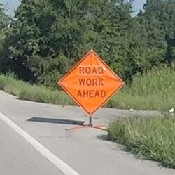
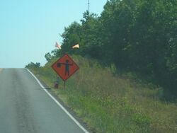
616.19.2.2.2 Sign and Flag Quality
- Acceptable Examples
-
 (1)
(1) -
 (2)
(2) -
 (3)
(3)


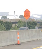
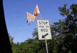
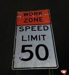
The signs in Pictures 1, 2 and 3 are considered in good quality. Supplemental devices such as flags and/or a cone may be placed next to a sign. Picture 2 is an example of the proper placement of a FLAGGER (WO20-7) sign, with the optional flags, in advance of the hill versus after the hill. In urban areas with barrier walls and narrow shoulders, a truncated sign may be used as shown in Picture 3.
- Note: TTCDs may be highly visible during the day but may not be at night due to inadequate retroreflectivity. MoDOT and Contractor representatives should drive through the work zone at night to check nighttime visibility.
- Unacceptable Examples
-
 (4)
(4) -
 (5)
(5) -
 (6)
(6) -
 (7)
(7) -
 (8)
(8) -
 (9)
(9)


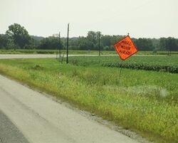
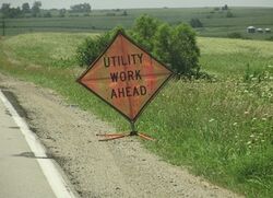
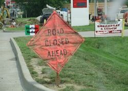
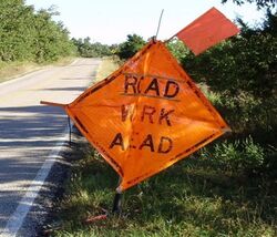
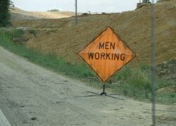
Pictures 4-7 are in unacceptable condition. Dirty or damaged signs should be cleaned, repaired, or replaced before being installed. When cleaning, follow manufacturer’s recommendations, so the daytime and nighttime visibility of the sign is not adversely impacted. The MEN WORKING sign (Picture 8) should be replaced with worker symbol sign or WORKERS sign (WO-21-1 or 1a) to meet current standards. Picture 9 shows unacceptable flags, if used, deteriorated flags should be replaced.
- Unacceptable Examples
-
 (10)
(10) -
 (11)
(11) -
 (12)
(12) -
 (13)
(13)


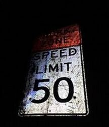
Pictures 10 - 13 are examples of unacceptable nighttime visibility. Proper storing, transporting, and covering signs is crucial to minimizing deficiencies.