903.9 General Information Signs: Difference between revisions
→903.9.14 State Line Signs (I2-1, I2-2, I2-3, I2-3P): updated per RR 3674 |
|||
| Line 429: | Line 429: | ||
{| style="margin: 1em auto 1em auto" | {| style="margin: 1em auto 1em auto" | ||
|- | |- | ||
|[[image:I2-1.jpg|center|thumb|140px|'''<center>I2-1'''</center>]]||[[image: | |[[image:I2-1.jpg|center|thumb|140px|'''<center>I2-1'''</center>]]||[[image:903.9.14_I2-2_I2-3_03-31-2023.png|center|thumb|140px|'''<center>I2-2'''</center>]]||[[image:903.9.14_I2-2_I2-3_03-31-2023.png|center|thumb|140px|'''<center>I2-3'''</center>]]||[[image:I2-3P.jpg|center|thumb|140px|'''<center>I2-3P'''</center>]] | ||
|} | |} | ||
| Line 440: | Line 440: | ||
'''Guidance.''' At locations where it may be impractical to erect the MISSOURI WELCOMES YOU sign at or near the state line, the MISSOURI STATE LINE sign should be used. At locations where the MISSOURI WELCOMES YOU sign is erected in addition to the MISSOURI STATE LINE sign, the MISSOURI WELCOMES YOU should be installed within ¼ mile of the state line. | '''Guidance.''' At locations where it may be impractical to erect the MISSOURI WELCOMES YOU sign at or near the state line, the MISSOURI STATE LINE sign should be used. At locations where the MISSOURI WELCOMES YOU sign is erected in addition to the MISSOURI STATE LINE sign, the MISSOURI WELCOMES YOU should be installed within ¼ mile of the state line. | ||
'''Option.''' The MISSOURI STATE LINE sign may be erected on other routes where it is impractical to use the Welcome to Missouri sign. | '''Option.''' The MISSOURI STATE LINE sign may be erected on other routes where it is impractical to use the Welcome to Missouri sign. | ||
==903.9.15 River and Major Lake Name (I3-1)== | ==903.9.15 River and Major Lake Name (I3-1)== | ||
Revision as of 08:14, 3 April 2023
903.9.1 Sizes of General Information Signs (MUTCD Section 2H.01)
Standard. Except as provided in EPG 903.2.13, the sizes of General Information signs that have a standardized design shall be as shown in Table 903.9.1.
Support. EPG 903.2.13 contains information regarding the applicability of the various columns in Table 903.9.1.
Option. Signs larger than those shown in Table 903.9.1 may be used (see EPG 903.2.13).
Table 903.9.1 Guide Sign Sizes
| Sign | Sign Designation | EPG Article | Conventional Road (in. x in.) | Freeway/Expressway (in. x in.) | ||
|---|---|---|---|---|---|---|
| Single Lane | Multi-Lane | Oversized | Mainline & Ramps | |||
| Emergency Reference | D10-5 | 903.9.4 | - | - | - | 18 X 60 |
| Auto Tour | M17 Series | 903.9.5 | Varies | Varies | - | Varies |
| Acknowledgement | I9-1, I9-1P, I9-1a, I9-1aP, I9-2, I9-2P, I9-3 | 903.9.6 | Varies | Varies | - | Varies |
| Airport | D4-10 | 903.9.7 | Var X 36 | - | - | - |
| Business District | D4-15 | 903.9.8 | 36 X 18 | 36 X 18 | - | - |
| Industrial Park | D4-16 | 903.9.8 | 48 X 36 | 48 X 36 | - | - |
| City Limit | I4-1, I4-1a, I4-2, I4-2b | 903.9.9 | Varies | Varies | - | Varies |
| Town | I5-1 | 903.9.9 | Varies | - | - | - |
| County Line | I6 Series | 903.9.9 | Varies | Varies | - | Varies |
| Custom City Limit | I4-1a, I4-2b | 903.9.11 | Varies | Varies | - | Varies |
| Custom County Limit | I6-1a | 903.9.11 | Var X 48 | Var X 48 | - | Var X 48 |
| Welcome To (for cities) | - | 903.9.13 | Varies | Varies | - | Varies |
| Missouri State Line | I2-1 | 903.9.14 | 36 X 18 | 72 X 36 | - | 72 X 36 |
| Missouri Welcomes You | I2-2, I2-3 | 903.9.14 | 96 X 48 | 96 X 48 | - | 144 X 72 |
| Welcome Center (for state line only) | I2-3P | 903.9.14 | - | - | - | 144 X 36 |
| Stream | I3-1, I3-1a | 903.9.15 | Varies | Varies | - | Varies |
| Transportation | I-5, I-7 | 903.9.16 | 24 X 24 | 24 X 24 | - | 30 X 30 |
| Veterans | - | 903.9.19 | Varies | Varies | - | Varies |
| College Generator | E12-1, E12-2, E12-2a, E12-3, E12-3a | 903.9.20 | - | - | - | Varies |
| College Emblem | E12-4, E12-4a, E12-5, E12-5a, E12-6, E12-6a, E12-7, E12-8 | 903.9.20 | - | - | - | Varies |
| College Destination | E12-1a | 903.9.20 | Varies | Varies | - | - |
| Correctional Center | - | 903.9.21 | Varies | Varies | - | Varies |
| Lewis and Clark | M17-2a | 903.9.22 | 24 X 30 | 24 X 30 | - | 24 X 30 |
903.9.2 General Information Signs (I Series) (MUTCD Section 2H.02)
Support. Of interest to the traveler, though not directly necessary for guidance, are numerous kinds of information that can properly be conveyed by General Information signs or miscellaneous information signs. They include such items as Missouri State line (I2-1), City limit (I4-1, I4-2a), unincorporated community signs (I5-1), County line (I6-1), and river names (I3-1).
Option. The pictograph of a political jurisdiction (such as a state, county, or municipal corporation) may be displayed on custom city limit or custom county line signs (see EPG 903.9.11). Pictographs are only used in accordance with MUTCD guidelines. The display of a pictograph is not a standard application, if a jurisdiction chooses to display a pictograph there is a fee associated with the installation and maintenance of the special signs covered by a MoDOT TR15 signing agreement with the city/county.
Standard. If used, the height of a pictograph on a political boundary General Information sign shall not exceed two times the height of the upper-case letters of the principal legend on the sign. The pictograph shall comply with the provisions of EPG 903.2.6.
903.9.3 Miscellaneous Information Signs (MUTCD Section 2H.04)
Support. Miscellaneous information signs are used to point out geographical features, such as rivers and summits and other jurisdictional boundaries.
Option. Miscellaneous information signs may be used if they do not interfere with signing for interchanges or other critical points.
Guidance. Miscellaneous information signs should not be installed unless there are specific reasons for orienting the travelers or identifying control points for activities that are clearly in the public interest. If Miscellaneous information signs are to be of value to the traveler, they should be consistent with other guide signs in design and legibility. On all such signs, the design should be simple and dignified, without any tendency toward flamboyant advertising and in general compliance with other signing.
903.9.4 Emergency Reference Markers (D10-5 and D10-5a) (MUTCD Section 2H.06)

Support. Emergency Reference Markers (D10-5 series) are used to assist travelers in estimating their progress, provide a means for identifying the location of emergency incidents and traffic crashes, and to aid in highway maintenance and servicing. The typical mile marker D10-1 series and intermediate mile marker D10-1a series of signs are not used by MoDOT as they do not provide the same level of information to the driver.
The Directional Ramp Emergency Reference Markers (D10-5a) are placed on long directional ramps to provide motorists a means to report incidents and/or request assistance. These signs help responders identify not only the interchange, but also the specific ramp they need to respond to.
Standard. Emergency Reference Markers (D10-5) shall be placed on Interstates (instead of traditional mile marker signs) at two-tenth mile intervals. An Emergency Reference Marker shall not be installed if it cannot be set within 200 ft. of its exact location.
Every attempt shall be made to install Emergency Reference Markers, even if this requires special mounting designs on walls, bridges or concrete median barrier.
Guidance. Directional Ramp Emergency Reference Markers (D10-5a) should be installed on directional ramps. These signs should be spaced approximately every 0.1 mile along the ramp with spacings being adjusted by engineering judgement to adjust for conditions.
Standard. Emergency Reference Markers (D10-5) shall be vertical panels having green backgrounds with white numerals, letters and borders, except for the route shield, which shall be the standard color and shape. The top line shall consist of the cardinal direction for the roadway. The second line shall consist of the applicable route shield for the roadway. The third line shall identify the mile reference for the location and the bottom line of the Emergency Reference Marker shall give the tenth of a mile reference for the location displaying the decimal point.
Directional Ramp Emergency Reference Markers (D10-5a) shall be vertical panels having green backgrounds with white numerals, letters, and borders, except for the route shield, which shall be the standard color and shape. The sign shall display the cardinal direction and route shield of the route being departed followed by “TO” and then display the cardinal direction and route shield of the route being accessed. Only the route shields for the primary routes shall be displayed on these signs, see Standard Plan 903.03 for installation details.
Emergency Reference Markers shall have a minimum mounting height of 4 ft. to the bottom of the sign according to the mounting height requirements of EPG 903.2.18 Standardization of Sign Location and per details found in Standard Plan 903.03.
The distance numbering shall be continuous for each route within the state, except where overlaps occur (see EPG 903.8.32). Where routes overlap, Emergency Reference Marker continuity shall be established for the route of higher classification. If two routes of the same class overlap each other, the route with the lower designation takes precedent unless that route overlaps for only a short segment.
Guidance. The route selected for continuity of distance numbering should also have continuity in interchange exit numbering (see EPG 903.8.32). On a route without Emergency Reference Marker continuity, the first Emergency Reference Marker beyond the overlap should indicate the total distance traveled on the route so that travelers will have a means of correlating their travel distance between Emergency Reference Markers with that shown on their odometer.
Standard. The distance measurement shall increase in the northbound and eastbound directions of travel. Emergency Reference Markers for southbound or westbound roadways shall be set at locations directly opposite to and displaying the same distance measurement as the Emergency Reference Marker for the northbound or eastbound roadways.
Guidance. The zero-distance should begin at the south and west state lines, or at the south and west terminus points where routes begin within a state.
Standard. Except as provided in the option below Emergency Reference Markers shall be installed on the right side of the roadway.
Option. Where conditions limit or restrict the use of Emergency Reference Markers on the right side of the roadway, they may be installed in the median. Emergency Reference Markers may be installed back-to-back if the median location is warranted. Emergency Reference Markers may be installed on non-interstate freeways and expressways under the following conditions:
- 1. Written support from the local response agency must first be obtained.
- 2. A logical beginning and ending point must be chosen. Examples of logical beginning or ending points include state boundaries, transitions from two to four lanes, or major intersections. District borders, county lines or construction project limits are not logical beginning and ending points.
- 3. All districts along the route must be involved in the decision to install Emergency Reference Markers on a route to ensure consistency of application.
Guidance. Emergency Reference markers should not be installed on routes which are likely to change in length due to future realignments. Roadway realignments would require the replacement of Emergency Reference Markers in the future to correct the distance measurement displayed on these signs.
903.9.5 Auto Tour Route Signs (M17 series) (MUTCD Section 2H.07)
 |
 |
 |
 |
 |
 |
 |
 |
 |
Support. An auto tour route is a path along a historic route or a historic trail with the auto tour route traversing existing roadways. The roadway the auto tour route traverses may be the actual historic road or represent the exact location of a historic trail, however, it is more common the auto tour route traverses existing roadways which represent the closest approximation of where the historic route or trail originally existed.
MoDOT does not typically initiate auto tour routes, this action is typically initiated by historical organizations like the National Park Service or private organizations like the Historic Route 66 Association of Missouri who have an interest in preserving the history of a historic route or trail. These organizations are the technical experts on the history of the historic route or trail.
Auto tour signing is expensive to install and maintain and these costs are generally borne by the sponsoring organization requesting the signing. One of the primary issues with auto tour routes is they traditionally rely on signs to guide motorists along the path. If just one sign is stolen or damaged and taken out of service, the path is broken, and motorists can lose their way. In today’s technology and GPS guidance, there may be better more cost-effective ways of guiding motorists along an auto tour route. A sponsoring organization may want to consider instead of signing, such as a navigational map app for smart phone or GPS system. These types of apps are cheaper, can be easily updated, and are not as susceptible to failures like physical signs.
Standard. The Commission will consider marking an auto tour trail if the historic route or historic trail meets these minimum qualifications:
- A. The road has been designated historic in one of the following ways:
- 1. The route is listed on the National Park Service’s National Register of Historic Places.
- 2. The route is a National Park Service National Historic Trail
- 3. The route has been designated as historic through state legislation or congressional action.
- B. An organization shall exist who sponsors the historic route and who shall be responsible for determining the exact path of the historical road.
- C. The historic route shall be a minimum of 50 miles long and contiguous in length.
Once a historic route or trail has been determined to qualify for auto tour signing, there are additional conditions and terms which must be met before signs can be installed on Commission right of way:
- A. There shall be an agreement between the sponsoring organization and the Commission to define the responsibilities of each party. The agreement will have a 10-year term with options to renew the agreement. A new agreement will be executed as part of the renewal period. Any changes to the agreement during the 10-year period will void the agreement.
- B. The sponsoring organization shall be responsible for paying a fee for the auto tour trail signing placed on Commission right of way. The fee shall be determined by the Commission and will cover the cost for initial sign installations as well as the estimated maintenance costs for the life of the 10-year agreement. If at the end of the 10-year term the sponsoring organization wishes to renew the agreement, the organization will be responsible for paying a renewal fee to cover the estimated maintenance costs for the subsequent 10 years. If a renewal is not executed with the Commission following the end date of the previous agreement the auto tour trail signing will no longer be maintained and will be removed from Commission right of way.
- C. Historic route signs located on MoDOT right of way shall be installed and maintained by MoDOT per the agreement. These signs will always remain the property of the Commission and at the end of their life span will be disposed of as scrap material.
- D. The Commission shall approve the path of the historic route prior to execution of the agreement.
- E. The design of the sign used to mark the historic route shall be approved by the Commission as well as the Federal Highway Administration. The size of the sign shall not be larger than 24” x 30”.
- F. The Commission shall coordinate the fabrication of the approved historic route signs for both state route and non-state route portions of the historic route or path to assure uniformity in signing.
- G. The installation of signs on Commission right of way shall be in accordance with MoDOT standards and specifications and approved by MoDOT prior to the execution of an agreement. The sign installations on routes outside of the Commission’s current right of way shall match the sign design and sign placement established for the state right of way, with the post selection meeting the approval of the local jurisdiction who owns the right of way the signs are being installed on.
- H. If the path of the historic route travels on roadways outside of the Commission’s current highway system, the sponsoring organization shall acquire written commitments from local jurisdictions to allow the historic route’s path to traverse the local jurisdiction’s routes prior to the execution of the agreement with the Commission. These written commitments must also address how the signs will be initially installed along the local jurisdiction’s route as well as the commitments for the long-term maintenance of the signs. If these commitments cannot be obtained the historic route signing cannot be installed.
- I. The auto tour path for the historic route shall be installed in a single phase within a year or less.
- J. Any part of the Commission-maintained system shall be limited to a maximum of three concurrent historic route and/or trail designations.
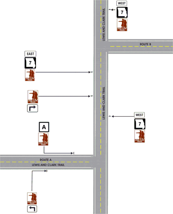
- K. The approved auto tour path shall be marked using trailblazer assemblies and confirmation assemblies installed on their own independent sign supports. The trailblazing assemblies shall comprise of one approved auto tour sign and the appropriate directional arrow. The confirmation assembly shall be comprised of only the approved auto tour sign. The confirmation assemblies shall be placed in advance of an intersection where the auto tour route makes a directional change, the confirmation assembly shall be installed downstream of the intersection where the auto tour route made the directional change. No other signs shall be installed along the route unless approved by the Commission. The Commission will work with the sponsoring organization to establish the sign installation plan identifying sign installation locations.
- L. Cardinal Direction plaques shall not be used with auto tour route signing.
- M. The AUTO TOUR (M17-1) auxiliary sign was an educational plaque, it is no longer used. All existing signs shall be removed from assemblies at the end of their life cycle.
The TR15 agreement for the auto tour route signing for sponsoring organizations who are not state or federal agencies shall contain the following provisions:
- A. The sponsoring organization for the historic route shall provide a detailed map and description for the path of the historic route to be included in the agreement between the sponsoring organization and the Commission.
- B. The sponsoring organization shall have the funding for the installation and 10 years of maintenance in place before the agreement will be executed.
- C. If the historic road crosses a state line, there must be agreement with the adjoining state or states on the signing and the routing of the historic route. If agreements with the other states cannot be reached the historic signing shall end at the last intersection in Missouri.
- D. If approved, Auto Tour Route signs shall not be installed on freeways or expressways, except as necessary to provide continuity between disconnected segments of conventional roadways that are designated as auto tour routes, for which the freeway or expressway provides the only connection between the segments. If installed on freeways or expressways, Auto Tour Route signs shall be installed as independent trailblazer assemblies and shall not be installed with other Route signs or confirmation assemblies or on guide signs. If installed on freeways or expressways, Auto Tour Route trailblazer assemblies shall be installed at less frequent intervals than route confirmation assemblies.
Support. Auto trail signing with state or federal sponsorship are typically installed under a memorandum of understanding (MOU), that is drafted specifically for each trail.
The Mississippi River Trail (MRT), while listed here, is a US Bike route which was established through the AASHTO Route Marking process. The MRT Trail is a designated bicycle and pedestrian trail that traverses the shores of the Mississippi River in the United States. The trail extends from the headwaters at Lake Itasca in Minnesota to near the mouth of the river in Venice, Louisiana. Much of the trail’s 3,000 miles (4,800 km) follows roadways used by motor vehicles, although some of the route is on multi-use trails.
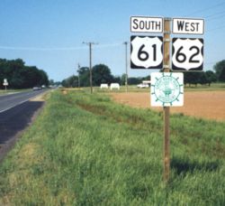
There are several approved historic routes and trails that follow state-maintained routes which include:
- A. Lewis and Clark Trail (M17-2)
- B. Historic 66 (M17-8, M17-8a)
- C. Santa Fe Trail (M17-4)
- D. Oregon Trail (M17-3)
- E. Trail of Tears (M17-5)
- F. Pony Express (M17-10)
- G. California Trail (M17-11)
- H. Mississippi River Trail (MRT) bike trail / US Bike Route 45 (M17-7)
Option. Exclusive to the Lewis and Clark Trail (M17-2) marker, signing may be placed on the Guide Signs to provide guidance along the approved path on freeways and expressways. If there is insufficient space on the guide sign to display the Lewis and Clark Trail, the trail sign may be hung below the guide sign in accordance with MoDOT Standards and Specifications.
903.9.5.1 Corridor Designations
 |
 |
Support. Corridor designations are typically multi-state route names established and/or implemented by neighboring state DOTs. In Missouri, the adoption of corridor designations was accomplished through Commission action.
There are two approved corridor designations currently in the state:
- Avenue of the Saints (M17-9) - The Avenue of the Saints was the concept of businessman Ernest Hayes of Mount Pleasant, Iowa who in the 1980s envisioned a four-lane highway between St. Paul and St. Louis. It was named by Gary Smith, who at the time was Executive Director of the Southeast Iowa Regional Planning Commission. Smith and Hayes convened a group of area business and political leaders, who organized an effort to convince the Iowa Department of Transportation to study the idea, which they did in 1988.
- In 1990 the FHWA chose its route for the Avenue of the Saints: the signed highway would follow the existing Interstate 35 from St. Paul to a point south of Clear Lake, Iowa; U.S. Route 18 to Charles City, Iowa; U.S. Route 218 to Cedar Falls, Iowa; U.S. Route 20 and Iowa Highway 58 around Cedar Falls and Waterloo, Iowa; Interstate 380 from Waterloo through Cedar Rapids to Interstate 80 near Coralville, Iowa and Iowa City, Iowa; U.S. Route 218 to Donnellson, Iowa; Iowa Highway 394 and Route B to Wayland, Missouri; and Interstate 64 and U.S. Route 61 from Wayland to St. Louis. The Intermodal Surface Transportation Efficiency Act of 1991 made the Avenue of the Saints an official "high-priority corridor," and signs were put along the route by the end of the year.
- On July 25, 2008, the final nine miles (14 km) of highway between the Lewis—Clark county line and Wayland, Missouri, was open to four-lane traffic. A ceremony was held at the intersection of US 61 and Route 27 to commemorate the completion of the four-lane highway in Missouri. The Avenue of the Saints is now complete from St. Paul to suburban St. Louis.
- Chicago - Kansas City Expressway (CKC) – The Chicago–Kansas City Expressway is a highway that runs between Chicago, Illinois, and Claycomo, Missouri. The road is known as Route 110 in Missouri and Illinois Route 110 (IL 110) in Illinois. The Illinois Route 110 was created through legislation on May 27, 2010, as the designated route for the Illinois portion of the Chicago–Kansas City Expressway.
- Missouri Route 110 and the Chicago-Kansas City Expressway designations were established through the actions of the Missouri Highways and Transportation Commission on January 4, 2012.
903.9.6 Sponsorship Signs (I9-1, I9-2, I9-2P, I9-3, I9-4) (MUTCD Section 2H.08)
 |
 |
 |
Support. Acknowledgment signs are a way of recognizing a company, business, or volunteer group that provides a highway-related service. Acknowledgment signs include, but are not limited to, sponsorship signs for adopt-a-highway litter removal programs, maintenance of a parkway or interchange, and other highway maintenance or beautification sponsorship programs.
Refer to EPG 141.8 Sponsorship Programs for more information on MoDOT's Sponsorship Policy.
Guidance. Refer to EPG 171 Maintenance Policy and Operations for acknowledgment sign program policy.
Standard. Because regulatory, warning, and guide signs have a higher priority, acknowledgment signs shall only be installed where adequate spacing is available between the acknowledgment sign and other higher priority signs. Acknowledgment signs shall not be installed in a position where they would obscure the road users’ view of other traffic control devices.
Acknowledgment signs shall not be installed at any of the following locations:
- A. On the front or back of, adjacent to, or around any other traffic control device, including traffic signs, highway traffic signals and changeable message signs;
- B. On the front or back of, adjacent to, or around the supports or structures of other traffic control devices, or bridge piers; or
- C. At key decision points where a road user’s attention is more appropriately focused on other traffic control devices, roadway geometry or traffic conditions, including exit and entrance ramps, intersections, grade crossings, toll plazas, roundabouts, temporary traffic control zones and areas of limited sight distance.
Guidance. The minimum spacing between acknowledgment signs and any other traffic control signs, except parking regulation signs, should be:
- A. 150 ft. on roadways with speed limits of less than 30 mph,
- B. 200 ft. on roadways with speed limits of 30 to 45 mph, and
- C. 500 ft. on roadways with speed limits greater than 45 mph.
If the placement of a newly installed higher-priority traffic control device, such as a higher-priority sign, a highway traffic signal or a temporary traffic control device, conflicts with an existing acknowledgment sign, the acknowledgment sign should be relocated, covered or removed.
Option. Acknowledgment signs may have their own designs and may also use their own pictograph and/or a brief jurisdiction-wide program slogan as part of any portion of the acknowledgment sign, provided that the signs comply with the provisions for shape, color, and lettering style in this article and in EPG 903.2 Extent of Signing.
Guidance. Acknowledgment signs should clearly indicate the type of highway services provided by the sponsor.
Standard. Acknowledgment signs shall comply with the following provisions:
- A. Neither the sign design nor the sponsor acknowledgment logo shall contain any contact information, directions, slogans (other than a brief jurisdiction-wide program slogan, if used), telephone numbers, or internet addresses, including domain names and uniform resource locators (URL);
- B. Except for the lettering, if any, on the sponsor acknowledgment logo, all lettering shall be in upper-case letters;
- C. In order to keep the focus on the highway-related service and not on the sponsor acknowledgment logo, the area reserved for the sponsor acknowledgment logo shall not exceed 1/3 of the total area of the sign and shall be a maximum of 8 sq. ft., and shall not be located at the top of the sign;
- D. The entire sign display area shall not exceed 24 sq. ft.;
- E. The sign shall not contain any messages, lights, symbols or trademarks that resemble any official traffic control devices;
- F. The sign shall not contain any external or internal illumination, light-emitting diodes, luminous tubing, fiber optics, luminescent panels, or other flashing, moving or animated features; and
- G. The sign shall not distract from official traffic control messages such as regulatory, warning, or guidance messages.
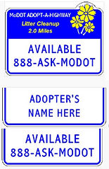
Guidance. In the spring of 2012 the design of Adopt-A-Highway signs changed from an all blue background (I9-1) to a blue and white background with an interchangeable plaque system (I9-1a and I9-1aP). This plaque system is designed to allow Adopt-A-Highway signs to remain standing when adopters enter and leave the program.
For new adoptions, the basic sign has a message of “AVAILABLE 888-ASK-MODOT” (I9-1a) and the plaque bearing the adopter’s name or message (I9-1aP) is installed over this message. When an adopter ceases participation in the program, the plaque should be removed, revealing the “available” message.
Additionally, “AVAILABLE 888-ASK-MODOT” plaques (I9-1P) may be placed on the older style signs (I9-1) when an adopter stops participating if the existing sign still has some remaining service life. Once a new adopter chooses this section of roadway, the “available” plaque (I9-1P) may be changed out with a new plaque bearing the adopters name or message (I9-1aP).
903.9.7 Airport Sign (D4-10)
 |
Support. MoDOT signs for both general aviation airports (public airports that do not offer commercial flights) and airports offering regularly scheduled commercial air service.
Standard. The Airport (D4-10) sign shall be used to sign general aviation airports and only at the first order sign location. If the first order signing location is at an interchange, only ramp terminal signing will be provided. Airport signing shall not be provided for privately owned airports or flying fields.
Supplemental guide signing shall only be used to sign for airports offering regularly scheduled commercial air service and only up to the third order sign location or the first interchange encountered.
The Airport (I-5) Symbol sign shall be reserved for guidance to airports offering regularly scheduled commercial service and shall not be used to provide guidance for airports that do not provide commercial flights. Airport (I-5) Symbol shall be incorporated into the supplemental guide sign designs.
Option. Signing for St. Louis Lambert International Airport and Kansas City International Airport may have additional guide signing beyond the third order locations and beyond the first interchange due to the fact they draw motorist from all over the state as well as neighboring states.
Airport (I-5) Symbol sign, with an arrow plaque, may be used as a trailblazer for airports offering commercial air service. The Airport (I-5) Symbol may be included on primary guide signs for exits which lead motorists in the direction of an airport offering regularly scheduled commercial air service.
903.9.8 BUSINESS DISTRICT and INDUSTRIAL PARK Signs (D4-15, D4-16)
 |
 |
Option. The BUSINESS DISTRICT (D4-15) sign may be erected on a highway within the city limits at the principal intersection leading to the central business district.
Standard. If a route passes through the central business district, this sign shall not be used.
If a route passes through the industrial park, this sign shall not be used.
Option. The INDUSTRIAL PARK (D4-16) sign may be erected on a highway within the city limits at the principal intersection leading to the central industrial park when truck traffic tends to get lost or miss turns.
Guidance. If used, the INDUSTRIAL PARK sign should be installed at first order signing for the most direct path.
903.9.9 City/County Limit Signs (I4, I5, I6 Series)
 |
Standard. The City Limit (I4 series) signs shall be erected at the city limit of each incorporated area, at the point where the city limit crosses the right of way. If there is inadequate space at this location to install a sign, the city limit sign shall be moved to the closest appropriate location within the city limit boundaries.
County Line (I6 series) signs shall be erected on all state routes at the county line boundary. If there is inadequate space at this location to install a sign, the county line sign shall be moved to the closest appropriate location within the county boundaries.
Support. Beginning July 1, 2021, city populations will no longer be included on city limit signs to comply with new guidance which will be included in the 11th edition of the MUTCD. The decision to phase out the display of populations on city limit signs prior to the release of the 11th edition of the MUTCD was due to the pending release of the updated US Census numbers. This was to avoid the significant expenditure of resources to update all existing city limit signs with new populations. Existing city limit signs will continue to display the city population until the end of the sign’s service life with no option to update the display. City limit and county line sign designs will also be modified to match the MUTCD standard layout of jurisdictional boundary signs currently used on Missouri’s State Line signs, displaying the proper name of the boundary followed by the boundary type.
Standard. City limit and county line signs shall only display the proper name of the incorporated community, or the proper name of the county, these jurisdictional boundary signs are marking, followed by the jurisdictional boundary description of “CITY LIMIT” or “COUNTY LINE” respectively. Names of elected officials or promotional messages, such as notable accomplishments or claims, shall not be displayed on, or with, city limit or county line signs.
Guidance. The County Line sign should not be erected at the state line.
Support. See EPG 903.16 Typical Signing Applications of City Limit signs.
Option. Unincorporated Community signs (I5-1) may be installed at the approximate entrance of an unincorporated community, similar to a city limit sign. Unincorporated communities eligible for signing are those that the traveling public would view or recognize as an organized community as they pass through the area. These unincorporated communities would typically have businesses, community centers, or other non-residential structures that are visible from the highway, in addition to their residential areas. They would also be significant enough to typically justify a reduction in the posted speed limit and/or be considered as a destination on highway signs. Eligible unincorporated communities are typically structured enough to also have some form of governing board or council.
Residential neighbor developments or subdivisions are not to be considered unincorporated communities that would qualify for highway signing. Regions that once were recognized by the traveling public as an unincorporated community but now have very little or no community recognizable features would no longer be eligible for signing. Existing Community boards installed for regions that are no longer eligible for signing shall remain in place until the end of their service life.
A Speed Limit sign may be mounted above the Unincorporated Community sign if the speed limit changes at that location.
903.9.10 Special Supplemental Signing
Support. Special supplemental signing policies contained in EPG 903.9.11 and EPG 903.9.12 refer to signs that are either modifications of existing MoDOT signs or special guide signs that have been approved for use. In many cases these signs are provided by MoDOT and have a participation fee associated with the fabrication, installation and maintenance of these special supplementary signs.
Guidance. Care should be taken when considering adding supplemental signs to make sure they do not interfere with or distract from regulatory, warning or guide signs. Sufficient spacing of at least 800 ft. on freeways or expressways should be allowed for drivers to be able to read and comprehend the sign messages.
903.9.11 Custom City Limit and Custom County Line Signs (I4-1a, I4-2b, I6-1a)
Support. Many cities and counties want to enhance their identity and presence to the traveling public. A way to do this is by requesting MoDOT to install customized city or county limit signs in lieu of the MoDOT standard jurisdictional boundary signs. Displaying the city or county logo or emblem along with the jurisdictional boundary information is in compliance with MUTCD standards. Standards have been developed, according to the MUTCD, as to what the signs will look like and what is allowed to be added to customize the signs. Custom signs are not required at city or county limits on the state system.
Incorporated communities are permitted to request that custom city limit signs be installed on the state system.
Standard. Any custom sign not conforming to this policy shall be removed.
MoDOT shall fabricate customized signs, for consistency, according to the standards described below. Graphics or messages requested by the city or county shall have the approval of the department prior to fabrication.
The signs shall be white legend on a green background. The signs shall be made of reflectorized material according to MoDOT standards. Lettering on the signs shall be of the approved size and style as contained in the MUTCD for the type of facility where the signs will go.
The left side of custom boundary signs shall display the standard message used on standard MoDOT-supplied city limit or county line signs with the right side of the sign displaying the official city or county logo or emblem (the square area in the sign images shown above). Logos of individual organizations shall not be allowed. The maximum size of the city or county logo (height and width) shall be two times the upper-case legend height of the city or county name displayed on the sign.
When a city or county elects to use a customized limit sign, MoDOT shall replace the standard sign with the custom sign. If there is a need for a speed limit sign, the speed limit sign shall be installed the same as if a standard city limit sign were used.
A participation fee shall be paid for by the city/county which will include all cost for fabrication, installation, and maintenance of the signs. Refer to EPG 903.15 Signing Agreements for contract process.
Lighting of these signs shall not be allowed.
Guidance. The TR-15 contract should be executed between the city or county and MoDOT before the sign is installed.
The legend of the sign should be simple, dignified and void of any commercial advertising.
Landscaping around any of these signs should be coordinated and reviewed by the department’s roadside management personnel.
903.9.12 City and County Accomplishment Plaques (I4-1P, I4-2P, I5-1P, I6-1P)
Support. MoDOT did have a city/county accomplishment program where a city or county could display up to three accomplishments below their jurisdictional boundary sign. This program was discontinued September 1, 2021 in response to pending federal rule changes that would prohibit such displays on jurisdictional boundary signs.
Standard. No new accomplishment plaque requests will be considered after September 1, 2021. All existing accomplishment plaques shall be maintained for the remainder of the 10-year term in accordance with the latest TR15 contract executed for each installation. No accomplishment contract will be renewed or extended beyond the contract termination date. All existing accomplishments listed on the plaques shall remain unchanged for the remainder of the contract terms. No additions, modifications or updates will be permitted.
903.9.13 Welcome To Signs for Cities
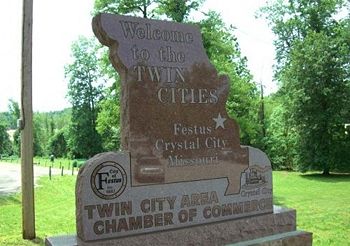
Option. Cities may place Welcome To signs on MoDOT right of way to welcome visitors to their city when their city limits encompass the intersection.
Welcome To signs may be made retroreflective.
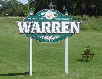
Standard. Welcome To signs shall fit on one or two MoDOT breakaway signposts (wood, PSST, pipe, structural) as a ground mounted sign only. Welcome To signs shall not be mounted overhead or on bridge structures, i.e. girders, columns abutment walls, etc.
Welcome To signs shall not be illuminated electrically.
Welcome To signs shall not contain advertisement of any kind.
Welcome To signs shall not provide directional guidance by displaying destinations with or without arrows.
A TR-42 agreement shall be executed before a Welcome To sign is installed.
Guidance. Welcome To signs should be installed in a location that does not interfere with normal highway signs and possess the least possible threat to the motorist should they leave the roadway.
The district should consider issuing a permit that would be tied to the installation of Welcome To signs to address details that are not covered in the TR-42 (such as locating utilities and traffic control responsibilities).
Support. The content and design of the sign face is up to the city. It is recommended the signs be retroreflective so they are visible at night and have the same appearance at night as they do during the day.
Guidance for Welcome To monuments can be found in EPG 941.5.
903.9.14 State Line Signs (I2-1, I2-2, I2-3, I2-3P)
 |
 |
 |
Standard. The MISSOURI STATE LINE (I2-1) sign shall be erected at the state line on all lettered routes.
The large MISSOURI WELCOMES YOU (I2-3) sign shall be erected at or near the state line on numbered routes where the traffic volume is 1,000 AADT or greater. The Welcome to Missouri Welcome Center (I2-3P) plaque shall be installed below a Welcome to Missouri (I2-3) sign on interstates when there is a welcome center located downstream from the state line.
The smaller sign (I2-2) shall be erected at or near the state line on numbered routes where the traffic volume is less than 1,000 AADT.
Guidance. At locations where it may be impractical to erect the MISSOURI WELCOMES YOU sign at or near the state line, the MISSOURI STATE LINE sign should be used. At locations where the MISSOURI WELCOMES YOU sign is erected in addition to the MISSOURI STATE LINE sign, the MISSOURI WELCOMES YOU should be installed within ¼ mile of the state line.
Option. The MISSOURI STATE LINE sign may be erected on other routes where it is impractical to use the Welcome to Missouri sign.
903.9.15 River and Major Lake Name (I3-1)

Guidance. River and Major Lake Name (I3-1) signs should be erected at all bridges on the interstate and numbered routes.
Standard. River and Major Lake Name signs shall not be installed on letter routes. Signs shall only be installed at bridges crossing the rivers and major lakes listed in Table 903.9.15; all other river and lake name signs currently in place shall be removed at the end of their life cycle.
Table 903.9.15
| Rivers That Will Receive "Stream Name Signs" |
Lakes That Will Receive "Stream Name Signs" | |
|---|---|---|
| Big Piney River | Bull Shoals Lake | |
| Big River | Harry S Truman Lake | |
| Black River | Lake of the Ozarks | |
| Blackwater River | Mark Twain Lake | |
| Bourbeuse River | Norfolk Lake | |
| Cache River | Pomme de Terre Lake | |
| Chariton River | Smithville Lake | |
| Cuivre River | Stockton Lake | |
| Current River | Table Rock Lake | |
| Des Moines River | Thomas Hill Reservoir | |
| Eleven Point River | Wappapello Lake | |
| Elk River | ||
| Fabius River | ||
| Fox River | ||
| Gasconade River | ||
| Grand River | ||
| Headwater Diversion | ||
| Jacks Fork River | ||
| James River | ||
| Kansas River | ||
| Lamine River | ||
| Locust Creek | ||
| Meramec River | ||
| Mississippi River | ||
| Missouri River | ||
| Moreau River | ||
| Nishnabotna River | ||
| North Fork White River | ||
| Niangua River | ||
| Nodaway River | ||
| North River | ||
| Osage River | ||
| Platte River | ||
| Pomme de Terre River | ||
| Sac River | ||
| Salt River | ||
| South Grand River | ||
| Spring River | ||
| St. Francis River | ||
| Tarkio River | ||
| White River | ||
| Wyaconda River |
Rivers which receive signing are those which drain the major watersheds of the state; however, individual watersheds of any size shall not be signed on MoDOT roadways.
Option. Individual arms of major lakes may be signed on interstate and numbered routes.
903.9.16 Transportation Signs (I-5, I-7, E11-1)
 |
 |
 |
Option. Guide signs for commercial service airports may be provided from the nearest interstate, or other freeway intersection directly to the airport, normally not to exceed 15 miles. The Airport (I-5) symbol sign along with a supplemental plaque may be used to indicate the specific name of the airport. An Airport symbol sign, with or without a supplemental name plaque or the word AIRPORT, and an arrow may be used as a trailblazer.
Standard. Adequate trailblazer signs shall be in place prior to installing the airport guide signs.
Support. Location and placement of all airport guide signs depends upon the availability of longitudinal spacing on highways.
Standard. When a sign is used to display a safety or transportation-related message, the display format shall not be of a type that would be considered similar to advertising displays. Messages and symbols that resemble any official traffic control device shall not be used on safety or transportation-related message signs.
The Amtrak Station (I-7) sign shall not be installed if a city will not provide supplemental signing for these locations.
The Amtrak Station and the appropriate M6 series arrow shall be used for ramp signs.
Guidance. The Amtrak Station sign should be compatible with the color and size of existing signing design.
Support. The Amtrak Station sign is a supplemental guide sign of variable size.
Standard. The “Missouri Train Service – 1-800-USA-RAIL – morail.org” sign has been discontinued. Existing signs shall be removed at the end of their service life.
903.9.17 Historic Downtown Signs
Standard. Historic Downtown Signs have been discontinued. MoDOT shall no longer provide signing for the historic business district of a community/city.
Existing Historic Downtown Signs shall be removed at the end of their service life.
Option. Signing for Historic Downtown Districts may be accomplished through the TODS (EPG 903.12) or Logo (EPG 903.11) programs.
903.9.18 Missouri Regional Port Authorities
Support. Signing for port authorities is done in coordination with Multimodal Operations. For more information contact Multimodal Operations.
903.9.19 Veterans Signing
Standard. MoDOT shall provide signing for veterans cemeteries in Missouri. The cemeteries shall be owned and operated by either the U.S. Department of Veterans Affairs (for national cemeteries) or the Missouri Veterans Commission (for state cemeteries). First order signing, on the state system, shall be provided for all cemeteries that meet the above upon request.
The Missouri Veterans Commission shall pay a participation fee for veterans’ home signs for 10 years. After 10 years, the signs will either be removed or renewed for another participation fee. All participation fees are to be determined by Traffic. First order signing, on the state system, shall be provided for all veterans’ homes that meet the above upon request.
Option. Second order signing may be considered if there is an intersection of a state route or an interchange within 6 miles of the cemetery or of the veterans’ home.
Signing may be allowed for veterans’ homes that are owned and operated by the Missouri Veterans Commission.
Standard. See EPG 903.10.7 HOSPITAL Signs for signing of Veterans hospitals
903.9.20 College Signing
Support. Prior to July 2015, MoDOT’s college signing was managed, installed and maintained by MoDOT. The rules for college signing were contained in the Code of State Regulations for Traffic Generator Signing as these signs are a form of traffic generator.
Effective July 1, 2015 a new Code of State Regulations, 7 CSR Division 10, Chapter 17 – Supplemental Guide Sign Program, went into effect that incorporated the rules for college signing.
College signing is now part of the Supplemental Guide Sign Program which is managed by a 3rd party contractor, beginning July 1, 2015.
Standard. All requests for college signing shall be sent to MoDOT’s Supplemental Guide Sign Program manager for processing.
This new CSR replaced those state administrative rules for individual programs and combined them into one unified rule. This new rule eliminated the duplications, corrected inequities and standardized definitions and requirements between programs. The new Supplemental Guide Sign Program CSR also permitted all programs contained within the rule to be outsourced. Outsourcing the management of these programs not only freed up MoDOT resources, but also provided one point of contact for interested applicants who prior to this may have had to contact both MoDOT and MoDOT’s former TODS and Logo program managing contractor.
A Request for Proposal (RFP) was advertised for the new Supplemental Guide Sign program and a contract was awarded on July 1, 2015. The signing programs managed under the Supplemental Guide Sign Program include:
- Tourist Oriented Directional Signing (TODS)
- Specific Service Signing (Logos)
- Traffic Generator Signing for privately owned and operated tourist-oriented activity sites
- College Signing
- Signing for State and Federal recreational and historic sites
- State Correctional Center signing
- Welcome Center Affiliate signing.
903.9.21 State Correctional Center Signs
Support. Prior to July 2015, MoDOT’s State Correctional Center Signing was managed, installed and maintained by MoDOT. The rules for correctional signing were contained in MoDOT policy in the EPG.
Effective July 1st 2015, a new Code of State Regulations went into effect, 7 CSR Division 10 , Chapter 17 – Supplemental Guide Sign Program, which incorporated the rules for State Correctional Center Signing. State Correctional Center Signing is now part of the Supplemental Guide Sign Program which is managed by a 3rd party contractor, beginning July 1, 2015.
Standard. All requests for State Correctional Center Signing shall be sent to MoDOT’s Supplemental Guide Sign Program manager for processing.
903.9.22 Lewis and Clark Historic Site Sign (M17-2a)
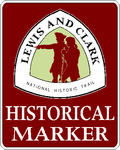
Standard. MoDOT shall provide signing for certified Lewis and Clark historic sites. Signing for sites shall direct motorists from the Lewis and Clark trail to the certified historic site. Signing for a certified site shall be limited to the nearest junction on the trail to the site. Second and third order signing on the trail shall not be allowed. Along the Mississippi River, where there is not an official Lewis and Clark trail, signing shall be provided from the “pseudo-trail” as designated by MoDOT.
Signing shall consist of the Lewis and Clark Historical Marker (M17-2a) sign and an appropriate Advance Turn Arrow placed in advance of the junction where motorists leave the trail. If additional trailblazers on the state system are required, the Lewis and Clark Historical Marker sign with the appropriate Advance Turn Arrow shall be used.
Additional trailblazing off the state system may be required to reach the certified historic site. This signing shall consist of the smaller version of the Lewis and Clark Historical Marker (M17-2a) sign, which is installed and maintained by others. MoDOT shall manufacture the Lewis and Clark Historical Marker signs with the cost of manufacturing reimbursed according to the following subarticles. Signing on the state system shall not be allowed unless the appropriate trailblazer signs off the state system are also installed, if required.
If a Public Area Directional sign does not exist for the facility, signing shall be provided according to the normal Lewis and Clark historic site policy.
Trailblazers shall be reimbursed by the appropriate state agency.
Requests for Lewis and Clark historic signing for a non-state owned location shall only be considered if the location has been certified by the National Park Service.
Signing for certified sites shall be in accordance with the normal Lewis and Clark historic site policy. The owner of the site shall be responsible for the cost and installation of the trailblazer signs and securing approval from the appropriate local agencies for locating and maintaining the trailblazer signs.
Guidance. The Missouri Department of Natural Resources and the Missouri Department of Conservation have erected special interpretive signs at some of their sites. The advance signs for these sites should be incorporated into any signing that currently exists for the facility by adding it above the existing Public Area Directional sign (see assembly above).
The Lewis and Clark Historical Marker sign should be mounted to either the left or right side of the Public Area Directional sign based on the turn required to reach the site.
Support. Information for certification can be found at:
- Lewis & Clark National Historic Trail
- 1709 Jackson Street
- Omaha, NE 68102-2571
- www.nps.gov/lecl/parkmgmt/site-certification.htm.
Information regarding the trail in Missouri can be found at:
- The Missouri Lewis and Clark Bicentennial Commission
- 100 Jefferson Street, Suite 200
- Jefferson City, MO 65101
- 573-522-9019
- https://mostateparks.com/park/lewis-and-clark-state-park.
Signing for certified sites will normally be from the approved Lewis and Clark trail. There are, however, several sites along the Missouri River in the north part of St. Louis County that are not conveniently located near the Lewis and Clark trail. Any signing provided along these routes will be in accordance with the normal Lewis and Clark historic site policy.
903.9.23 Historical Site Signs
Support. Prior to July 2015, MoDOT’s historic signing was accomplished through several different programs, Traffic Generator Signing and State and Federal Historic Site signing, these programs were managed, installed and maintained by MoDOT. In addition, historic sites could also be signed through MoDOT’s TODS and Logos program, managed by MoDOT’s TODS and Logos 3rd party contract manager. The rules for Traffic generator signing and well as TODS and Logos signing were all contained in individual Codes of State Regulations while the rules for state and federal historic site signing were contained in policy within the EPG.
Effective July 1st 2015, a new Code of State Regulations went into effect, 7 CSR Division 10 , Chapter 17 – Supplemental Guide Sign Program, which incorporated the rules for Traffic Generator Signing, TODS, Logos as well as for State and Federal Historic site signing.
These programs are now part of the Supplemental Guide Sign Program which is managed by a 3rd party contractor, beginning July 1, 2015.
Standard. All requests for Historic Site Signing shall be sent to MoDOT’s Supplemental Guide Sign Program manager for processing.
Support. There are some historical sites which MoDOT staff still install and maintain signs for, these are sites that have “national prominence” and are “nationally known” and are signed at the Commission’s expense.. Table 903.9.23 shows the list of sites that are considered to have “national prominence” and are “nationally known” and are the historic sites the Commission deemed to be of such importance as to justify such signing per Missouri State Statue 226.525 for the signing of natural wonders and historic attractions. Other historic sites have the option for signing under the Supplemental Guide Sign Program.
Table 903.9.23 Nationally Known, Nationally Prominent Sites
| Non-contractual Sites |
|---|
| Daniel Boone's Home |
| General Pershing's Boyhood Home |
| George Washington Carver Nat'l Monument |
| Harry S Truman's Birthplace |
| Mark Twain’s Boyhood Home and Museum |
| Route 66 State Park |
| Scott Joplin House |
| Trail of Tears State Park |
| Ulysses S. Grant National Historic Site |
| Wilson's Creek National Battlefield Park |
| National Churchill Museum |
903.9.24 Blue Star Markers (TR42-4)

Option. Blue Star Markers may be placed on the following routes: Route 36, Route 50, Route 67, I-44 and I-70. These signs are normally located in a rest area or roadside park. These signs are provided and maintained by others.
Standard. Approval for signing shall be obtained from the National Garden Clubs, Inc. prior to the erection of any new signs.
903.9.25 State Historical Society Markers
Support. On November 1952, the Commission entered into an agreement with the Missouri Historical Society for the erection of markers along the highways of Missouri at points of great historic interest. These signs are provided by others, normally in a rest area, roadside park or at a specific location of historical interest.
903.9.26 Local Reference Signs
 |
 |
 |
 |
 |
 |
 |
Support. Local Reference signs are small guide signs installed and maintained by a city or county on state right of way under a TR42 agreement. These signs provide guidance to city or county owned and maintained community sites which do not qualify for one of MoDOT’s supplemental guide sign programs.
Typical examples of sites that would qualify for Local Reference signing include, but not limited to:
- City Hall
- Police Station
- Courthouse
- City/County Park
- City/County Pool
- Senior Center
- Recycling Center.
Standard. Local Reference signs shall be 24 in. x 24 in. white on green guide signs with a directional arrow below the sign legend. The sign legend shall be limited to the generic name of the site, such as CITY PARK, and shall not include the proper name of the facility or the city / county name. Central Office Highway Safety and Traffic shall approve site types being requested for Local Reference signs and shall provide the sign design detail these signs shall be fabricated to match.
Local Reference signs shall only be placed at the first order sign location where motorists leave the state highway system. If the first order location is an interchange, the Local reference sign shall only be placed at the ramp terminal. Local refence signs shall not be placed on interstate highways or freeways. These signs shall only be installed on expressways with speed limits of 45 mph or less or on any conventional two-lane route.
A maximum of two Local Reference Signs on a maximum of one post shall be permitted at any given first order location. Local Reference signs shall direct motorists to the site along the most direct path possible. If the most direct path is not the same for the two directions of travel on the state route, the Local Reference signs for each direction shall be placed at two appropriate first order locations.
Local reference signs and posts shall be provided, installed, and maintained by the city/county under a TR42 agreement, and the district shall approve all locations. Local reference signs shall be fabricated to MoDOT’s sign design details and shall meet minimum MUTCD standards for color, and retroreflection.
Guidance. Sites receiving Local Reference signing on MoDOT right of way could require additional trailblazer signing on city/county right of way to provide a complete path to the site. This signing is also the responsibility of the city/county to install and maintain. Trailblazer signs should match the same design, color and size as Local Reference signs so they are clearly associated with the first signs they see on MoDOT right of way.
903.9.27 Community Awareness Signs
Support. Many communities cities/counties participate in programs sponsored by different agencies or groups. Some of these programs provide signs that the cities/counties then wish to post with the city limit sign want to post to acknowledge their participation. Cities/counties must achieve the minimum program requirements outlined by each sponsoring organization in order to qualify and/or continue to qualify for. Signing for the following programs are approved for installation on right of way:
- A. Storm Ready Program – Administered by National Weather Service program.
- B. Disaster Resistant Community Program - Sponsored by FEMA and locally coordinated by SEMA.
- C. Missouri Community Betterment Program - Administered by the Missouri Community Betterment Education Fund, Inc.
- D. TREE CITY U.S.A. Program – Administered by National Arbor Day Foundation.
- E. National Neighborhood Watch Program – Administered by the National Sheriff’s Association
- F. MADD Program – Administered by Mothers Against Drunk Driving
- G. D.A.R.E. Program - Administered by the MSHP in conjunction with local law enforcement
- H. Purple Heart City/County – Administered by the Military Order of the Purple Heart
- I. POW-MIA City/County – Administered by the Jefferson Barracks POW-MIA Museum
- J. Agri-Ready County - Administered by Missouri Farmers Care / Dept. of Agriculture
- K. Firewise USA Program – Administered by the National Fire Protection Association
Standard. Community awareness signs shall not detract from MoDOT signs and maintenance of the roadway. The signs shall look professional, not contain advertising of any kind. These signs shall not be displayed on interstates or freeways. These signs shall only be installed on expressways with speed limits of 45 mph or less or on any conventional two-lane route. These sign assemblies shall be placed adjacent and to the right of the city limit sign to tie the message to the community. The number of community awareness signs adjacent to any given city limit will be limited to two signs installed on one common post. No community awareness sign shall be mounted to a MoDOT post assembly.
Cities shall not fabricate their own copies and/or versions of the official signs Community Awareness programs, only those signs provided by the sponsoring organization can be installed on MoDOT right of way.
Option. If there is not room to place community awareness signs adjacent to the city limit sign, the community awareness assembly may be located 200 feet down stream of the city limit sign.
DARE signs may also be located at the right of way line on routes that pass along school properties.
903.9.28 Municipal Bus Stop Signing
Support. Many cities operate public transportation that includes bus service. With many MoDOT routes running through cities and serving as city streets, bus stop locations many times are located on MoDOT routes.
Guidance. Bus stops should not be permitted on freeways and should be established only with the approval of the District Engineer.
The location and spacing of the stops shall be consistent with both the needs of the bus passenger and a desirability of minimizing traffic flow disruption and operational hazards. Where bus stops are located at intersections, every effort should be made to place them on the far side unless operational considerations clearly indicate otherwise. Every effort should be made to locate the bus stops off the traveled portion of the roadway.
The shoulder width should be sufficient to allow clearance between the parked bus and the pavement and also permit storage of passengers and loading of the bus.
Signing for bus stops should be installed and maintained by municipality forces with standard red on white "No Parking - Bus Stop" signs following enactment of an enabling ordinance either on a blanket or specific location basis.
No other bus system signing, such as trail blazing for bus routes, should be permitted on the state system.
Option. Where a special need exists, the shoulder may be improved for safety and maintenance reasons.
Local bus officials may be permitted to install supplementary plates bearing schedules for the particular stop and other information relating to the bus operation. Distinctive bus system logos may be permitted on the supplementary signs provided they are of a configuration which will not prove distracting to motorists. These supplementary signs should be installed beneath the municipality signs.
Signing for other mass transit systems, including park and ride lots associated with the system, will be allowed under guidelines similar to bus stops.
If the mass transit system has a logo, they may incorporate it into their sign.


